


La Peyrouse au départ du Majeuil

Emelle
User
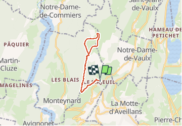

Length
10.8 km

Max alt
1707 m

Uphill gradient
775 m
Km-Effort
21 km

Min alt
970 m

Downhill gradient
776 m
Boucle
Yes
Creation date :
2020-01-09 08:43:06.862
Updated on :
2020-01-09 14:12:46.902
5h28
Difficulty : Medium

FREE GPS app for hiking
 SityTrail
IGN / Geographical institutes
SityTrail Plus
The world is yours!
About
Trail Walking of 10.8 km to be discovered at Auvergne-Rhône-Alpes, Isère, La Motte-Saint-Martin. This trail is proposed by Emelle.
Positioning
Country:
France
Region :
Auvergne-Rhône-Alpes
Department/Province :
Isère
Municipality :
La Motte-Saint-Martin
Location:
Unknown
Start:(Dec)
Start:(UTM)
715061 ; 4983801 (31T) N.
Comments